
Starkweather Creek Watershed Study
Last Updated: 05/25/2023
Latest Update
10/26/2022 Update:
The computer modeling is almost calibrated/verified for the current, or, existing conditions modeling. Results will be shared when they are available.
Complete a survey to help City Engineering prioritize flooding improvement projects.
Project Overview
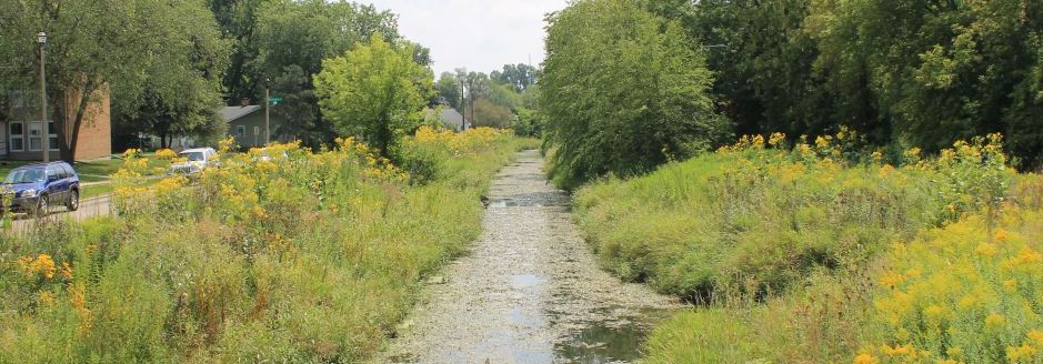
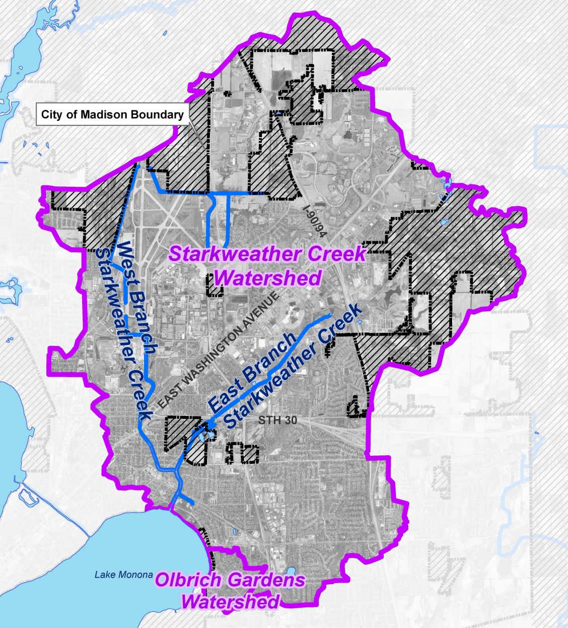
The City of Madison hired a consultant (Stantec, Inc.) to conduct advanced watershed modeling and planning services for the Starkweather Creek and Olbrich Gardens Watersheds in the City of Madison, WI. This is the largest watershed study area in the City, and in some cases, the most complex.
The beginning of the process is to create a computer model that represents the existing flooding conditions in the watershed. Once the computer model is created and verified, then the consultant will begin develop actionable mitigation measures to meet the City’s targets of reducing damages associated with flooding events, prioritizing for flood mitigation projects, and providing enough guidance to budget for the construction of projects identified in the watershed plans.
- In Phase 1 the team will be developing a model conducting an analysis of existing conditions and preparing conceptual level mitigation alternatives.
- In Phase 2 the team will cover more detailed modeling of preferred mitigation measures and cost-benefit and design feasibility analyses.
- In Phase 3 the team will cover final modeling, mitigation alternative refinement and report documentation.
For more information please see the Flash Flooding Story Map . *Note: Please view the story map using Firefox or Google Chrome browsers. Story maps are not viewable with Internet Explorer
The City of Madison, like many communities, has seen a recent increase in extreme flood events. This increase has occurred most notably in Madison since 2016, when a large and intense rain event in late July caused extensive flooding of public and private property on Madison’s west side. Large events in July 2017 and June 2018 caused similar flooding, again largely focused on Madison’s west side.
On August 20, 2018, Dane County experienced an unusual precipitation event that caused flooding in excess of that seen in any of the prior events mentioned. Rain gages monitoring that event registered between 3-4” of precipitation on Madison’s east side and 8-10” of precipitation on its west side over (approximately) a 12-hr period. Many of Madison’s west side neighborhoods experienced flash flooding, resulting in millions of dollars in property damage.
In response to the damage incurred due to recent extreme rainfall events, as well as the likely increasing frequency of such events due to global climate change, the Madison Common Council authorized the City of Madison Engineering Division (City Engineering) to develop watershed models and plans for watersheds of greatest concern in the Madison area.
Rain and Runoff Monitoring
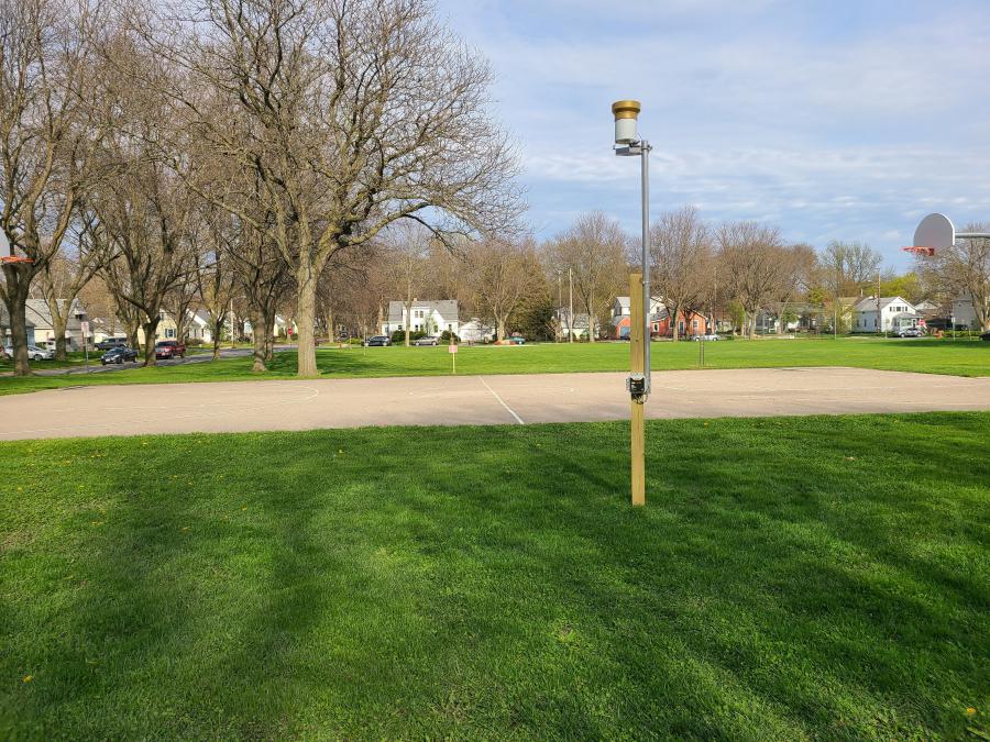
As part of the watershed study process, the City (in coordination with the United States Geological Survey (USGS)) has installed rain gages and runoff depth and flow gages in select locations in the watershed. These gages measure the depth of rain or runoff during a storm event. The information is collected and then used to verify the computer model's results. The two photos below show an example of the gages.

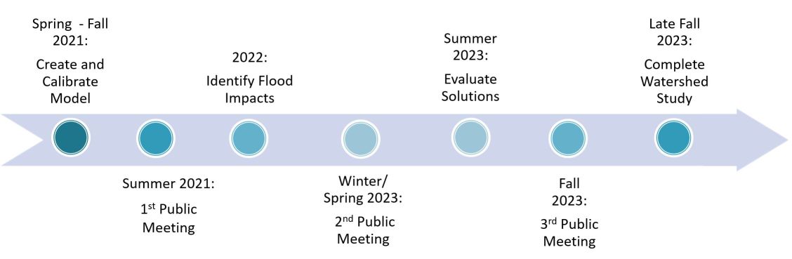
Project Schedule
The study is expected to take 36 months to complete due to the relatively large size of the watershed. The first activities will include numerous data and information collection and development of the public involvement plan.
Public Involvement
Questions and comments can be emailed to the Project Contact at anytime. There are also a number of points of contact during this project where the public is encouraged to give feedback. Information is summarized below:
- Public Information Meeting No. 1: Sept.16, 2021
- Focus Groups Round No. 1: Winter/Spring 2023
- Public Information Meeting No. 2: Spring 2023
- Focus Groups Round 2: Summer 2023
- Public Information Meeting No. 3: Fall 2023
Public Information Meetings
If you are interested in attending a public information meeting to find out what is happening with the watershed study and provide feedback, there are many ways to be notified. You can do one or all of the following:
- Sign up to receive updates
- Be on the look-out for the postcard announcing each meeting
- Check the project website
The public information meetings will be virtual meetings for all residents living in the watershed. City Engineering will share information on the progress of the study and ask for feedback.
Sept. 16, 2021 Public Information Meeting Recording
Sept. 16, 2021 Public Information Meeting PowerPoint Presentation
Focus Groups/Stakeholder Meetings
The Focus Groups and Stakeholder Meetings will be meetings for a subset of the residents in the watershed and could be for a neighborhood, a friend's group, a cultural/community organization, etc.
The purpose of the Focus Group and Stakeholder Meetings is to find out more in-depth information from interested residents in the watershed.Assuming COVID-19 guidelines allow, the meetings will be held in person, at a location suggested by the Focus Group/Stakeholder leader(s).If you are interested in attending a focus group or stakeholder meeting to discuss the future of the watershed, please reach out to the City Project Manager for the Study, Caroline Burger.
Prioritization Survey
There are many proposed recommendations from each watershed study. The cost of the recommendations far outweighs the City's budget to implement them. The public is asked to complete a survey to help the City prioritize which solutions are implemented first.
Complete a survey to help City Engineering prioritize flooding improvement projects.
Background
The City of Madison has 22 watersheds. Watersheds are an area of land that drain to the same location (the outlet).
There is a stormwater drainage system in all watersheds. This system is what conveys the stormwater to the outlet of the watershed. The current statistics on the City of Madison's stormwater drainage system can be found on the Stormwater webpage.
The City's system dates back to the 1880s. Very few, if any, standards were available in the 1880s. As the City developed, so did the guidance for design and construction. Today, we have comprehensive City, State, and Federal regulations to guide design and construction. The area of the City you live in used the regulations in place at the time it was developed. You can view the StoryMap to see what the regulations were for your neighborhood.
The extreme storm events in 2018 shed light on the deficiencies of the City’s stormwater drainage system. Many areas of the City experienced devastating flooding. This prompted the City to begin a comprehensive watershed study program in 2019. The intent of the program is to study each of the City’s watersheds one-by-one. The studies will help us to understand the causes of flooding. The studies will also provide recommended solutions to reduce the risk of flooding.
The watershed studies result in a list of proposed mitigation measures. Once constructed, the measures will reduce the risk of flooding to specific areas of the City. These mitigation measures are generally very costly. Due to limited stormwater management funding, all the mitigation measures cannot be implemented at one time.
The average Stormwater Utility Capital Budget each year is approximately $12 million. Within that, an average of about $2.4 million is used for flood mitigation. As of late 2021, recommended flood mitigation measures for the first five watershed studies were identified. The total cost from the first five studies is approximately $125 million. We expect the remaining 17 watershed studies will have similar flood mitigation project needs. Implementation of these flood mitigation measures will take many decades.
The Stormwater Utility funds the stormwater management for the City. This includes the construction, operation, and maintenance of the entire stormwater drainage system. The Stormwater Utility rates are set each year consistent with Wisconsin Statute. § 66.0821(4) and as described in Madison General Ordinance section 37.05. These rates are under the purview of the public service commission. The rates are required to be deemed “reasonable” to comply with state statute. During the annual budgeting process, the City tries to balance the stormwater needs with the stormwater rate charged to its customers. These needs include:
- Implementation of flood mitigation measures
- Replacement, extension, and upgrades of existing the existing stormwater system
- Mandated water quality needs and requirements
When possible, the City attempts to get grant funding to partially fund the flood mitigation measures. Grant funding makes up a small part of the funding needed for stormwater management.
The City has created a draft prioritization process. This process creates a proposed order to construct the flood mitigation measures. This process accounts for many factors including:
- Impact on emergency services,
- Location of vulnerable populations,
- If the project also improves stormwater quality,
- Whether other projects are occurring nearby, and
- If outside funding is available.
Additional Resources
If you have questions, or are looking for additional information, please see the resources below:
- City of Madison Flood Website
- Flash Flooding Resilience Story Map *Note: Please view the story map using Firefox or Google Chrome browsers. Story maps are not viewable with Internet Explorer.
- Watershed Study Learning Hub
- Engineering Waterways Newsletter 2020 Issue
- Watershed Studies 2019 Audio Presentation
- Flood Prevention Flyer and website
- Everyday Engineering Podcast Episode: Basement Drainage
- Everyday Engineering Podcast Episode: Historic Flooding
- Everyday Engineering Podcast Episode: What's going on with the Watershed?
Report Flooding
If anyone has experienced flooding, and is willing to share with the City, please report it on the City's website. Even if a homeowner reported flooding to 2-1-1, FEMA, or a City official, the City needs standardized information to create stormwater models that show existing flooding conditions. The flood data helps the City prioritize different flood projects and future watershed studies. Please report any flooding you’ve experienced.