
Central Isthmus Watershed Study
Last Updated: 05/03/2023
Project Update
9/2/2022 Update:
Sept. 1, 2022 Public Information Meeting Recording
Sept. 1, 2022 Public Information Meeting PowerPoint Presentation
Project Overview
The City of Madison is completing a watershed study in the Central Isthmus watershed (as shown below). The City of Madison contracted with Tetra Tech to complete the study. The watershed study will identify causes of existing flooding and then look at potential solutions to try to reduce flooding. The study will use computer models to assist with the evaluations.
For more information please see the Flash Flooding Story Map . *Note: Please view the story map using Firefox or Google Chrome browsers. Story maps are not viewable with Internet Explorer.
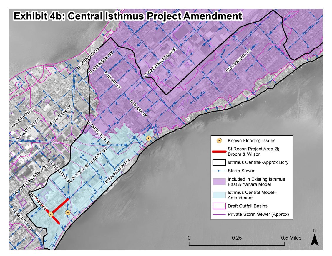
The Isthmus Central watershed (shown in light blue) drains to Lake Monona through several storm sewers.
Still have questions? Get some answers here from our additional information page on the Watershed Studies.
Project Schedule
The study began in October 2021 and is expected to be completed at the end of 2022.
Public Engagement
Questions and comments can be emailed to the Project Contact at anytime. There were also a number of points of contact during this project where the public was encouraged to give feedback. Information is summarized below:
Public Information Meetings
Sept. 1, 2022 Public Information Meeting Recording
Sept. 1, 2022 Public Information Meeting PowerPoint Presentation
Focus Group Meetings
Due to the shorter duration of this watershed study, formal Focus Group Meetings will not be conducted. The City has received a lot of feedback and met with residents in known flooding areas and has a strong understanding of the existing issues. The public is encouraged to provide feedback directly to the project manager, and to continue to report flooding online—see below.
Prioritization Survey
There are many proposed recommendations from each watershed study. The cost of the recommendations far outweighs the City's budget to implement them. The public is asked to complete a survey to help the City prioritize which solutions are implemented first.
Complete a survey to help City Engineering prioritize flooding improvement projects.
Report Flooding
If anyone has experienced flooding, and is willing to share with the City, please report it on the City's Report Flooding Portal. Even if a homeowner reported flooding to 2-1-1, FEMA, or a City official, the City needs standardized information to create stormwater models that show existing flooding conditions. The flood data helps the City prioritize different flood projects and future watershed studies.
The key to good reporting is including specific details and visuals.
If it is possible to do so safely, collect the following information when it is flooding:
- Date of the flooding
- Total time flooding occurred
- The time the flood water reached its highest point
- Photos of flooded areas when they are the most flooded
- Videos showing how the water is moving into and out of the flooded area
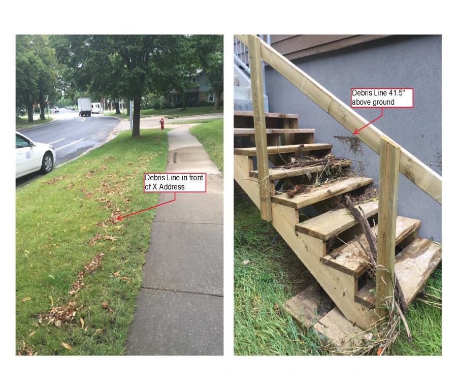
Once the flood waters have receded, and it is safe to do so, look for clues of the flood waters extent and depth. Clues include:
- Debris lines outside (twigs, leaves, dirt are left behind in a line on the lawn, sidewalk, mailbox post, shrub etc)
- Border of disturbed vegetation—if half the vegetation has been bent or is stuck to the ground in the direction of the flow, you can see the reach of the flood water
Document these clues and measure any depths where debris lines are above the ground. Pictures with descriptions are very helpful. For example:
If you were unable to capture any photos, descriptions are also helpful:
- Flood water reached the base of the first step on the front walk of our house at X address.
Flood water was 12” deep at the mailbox in front of X address
Existing Conditions Flood Mapping
The watershed model evaluated numerous design storm events. The City created an online viewer for the 1% chance (100-yr) storm event. Once the existing conditions flood mapping is finalized for the Central Isthmus watershed, it will be added to the map. It can be found here.
Proposed Flood Reduction Solutions
Proposed solutions information will be posted here when it is available.
Background
The City of Madison has 22 watersheds. Watersheds are an area of land that drain to the same location (the outlet). There is a stormwater drainage system in all watersheds. This system is what conveys the stormwater to the outlet of the watershed. The current statistics on the City of Madison's stormwater drainage system can be found on the Stormwater webpage.
The City's system dates back to the 1880s. Very few, if any, standards were available in the 1880s. As the City developed, so did the guidance for design and construction. Today, we have comprehensive City, State, and Federal regulations to guide design and construction. The area of the City you live in used the regulations in place at the time it was developed. You can view the StoryMap to see what the regulations were for your neighborhood.
The extreme storm events in 2018 shed light on the deficiencies of the City’s stormwater drainage system. Many areas of the City experienced devastating flooding. This prompted the City to begin a comprehensive watershed study program in 2019. The intent of the program is to study each of the City’s watersheds one-by-one. The studies will help us to understand the causes of flooding. The studies will also provide recommended solutions to reduce the risk of flooding.
The watershed studies result in a list of proposed mitigation measures. Once constructed, the measures will reduce the risk of flooding to specific areas of the City. These mitigation measures are generally very costly. Due to limited stormwater management funding, all the mitigation measures cannot be implemented at one time.
The average Stormwater Utility Capital Budget each year is approximately $12 million. Within that, an average of about $2.4 million is used for flood mitigation. As of late 2021, recommended flood mitigation measures for the first five watershed studies were identified. The total cost from the first five studies is approximately $125 million. We expect the remaining 17 watershed studies will have similar flood mitigation project needs. Implementation of these flood mitigation measures will take many decades.
The Stormwater Utility funds the stormwater management for the City. This includes the construction, operation, and maintenance of the entire stormwater drainage system. The Stormwater Utility rates are set each year consistent with Wisconsin Statute. § 66.0821(4) and as described in Madison General Ordinance section 37.05 . These rates are under the purview of the public service commission. The rates are required to be deemed “reasonable” to comply with state statute. During the annual budgeting process, the City tries to balance the stormwater needs with the stormwater rate charged to its customers. These needs include:
- Implementation of flood mitigation measures
- Replacement, extension, and upgrades of existing the existing stormwater system
- Mandated water quality needs and requirements
When possible, the City attempts to get grant funding to partially fund the flood mitigation measures. Grant funding makes up a small part of the funding needed for stormwater management.
The City has created a draft prioritization process. This process creates a proposed order to construct the flood mitigation measures. This process accounts for many factors including:
- Impact on emergency services,
- Location of vulnerable populations,
- If the project also improves stormwater quality,
- Whether other projects are occurring nearby, and
- If outside funding is available.
Additional Resources
- City of Madison Flood Website
- View the City's Annual Stormwater Newsletter: Waterways
- Flash Flooding Resilience Story Map *Note: Please view the story map using Firefox or Google Chrome browsers. Story maps are not viewable with Internet Explorer.
- Watershed Study Learning Hub
- Watershed Studies 2019 Audio Presentation
- Flood Prevention Flyer and website
- LISTEN: Everyday Engineering Podcast Episode: Basement Drainage
- LISTEN: Everyday Engineering Podcast Episode: Historic Flooding
- LISTEN: Everyday Engineering Podcast Episode: What's going on with the Watershed?