Moving forward: City releases plan, new resource for watershed studies
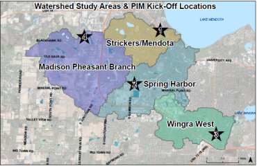
The City of Madison Engineering Division released its plan for upcoming watershed studies public information meetings. The Division also posted a new interactive map for the community to keep updated on the progress in each watershed study. This is a continued effort to address areas hardest hit by flooding last summer.
A watershed is an area of land where precipitation that falls on it, drains to a common waterway, such as a stream or lake. The watershed acts like a funnel by collecting all the water within the area and channeling it to a single point.
The new map on the City’s flooding webpage links to each specialized watershed study page, which has information on the project timeline, educational resources for residents, ways to report flooding data to help engineers pinpoint areas of concern and a map of the area to be studied in 2019. The pages will be updated with new information periodically.
The public information meetings will allow the community to take part in the watershed studies, which will help City engineers identify existing flooding problems, develop solutions and prioritize improvements.
These studies became a priority after extreme flooding, particularly in the west and far west side of Madison, and large rain events in the area the past three years (2016, 2017 and 2018). The City approved a budget amendment in November 2018 to fund the studies.
The studies are expected to take over 18 months. During this time, the city will look at watersheds as a whole to make sure solving a flooding problem upstream won’t push more water downstream and cause more flooding.
By completing these studies, the City engineers can create models of the existing infrastructure within a watershed and see where flooding may happen during different sized storms. From there, the City can simulate how solutions will impact the whole system.
Public information meetings are scheduled:
- Strickers/Mendota Watershed Public Information Meeting
- 6-8 p.m., April 22, Asbury United Methodist Church, 6101 University Ave.
- Spring Harbor Watershed Public Information Meeting
- 6-8 p.m., April 25, Madison Memorial High Auditorium, 201 S Gammon Rd.
- Wingra West Watershed Public Information Meeting
- 6-8 p.m., May 1, Cherokee Middle School Cafeteria, 4301 Cherokee Dr.
- Madison Pheasant Branch Watershed Public Information Meeting
- 10 a.m.-12 p.m., May 4, Edgewood College -- Deming Way Campus, 1255 Deming Way, Room 150-153
Children are welcome to attend meetings, but childcare is not provided.
Eventually, the City plans to complete watershed studies city-wide, but will prioritize the above based on extreme flooding from Summer 2018. In all, there are eight watersheds the City will focus on in 2019.
If a homeowner is not sure which watershed his or her property is included in, click to the City’s flooding website to use the new interactive map, report and sign up for updates.
Other resources to stay informed about watershed studies:
- City’s Facebook page events for meetings
- Sign up for email list on City’s flooding website for individual studies and flooding updates
- Sign up for flooding text alerts
- Report flooding, sign up for email updates for the City to use in watershed studies
Contacts
- Hannah Mohelnitzky, Public Information Officer, Engineering Division, 608-242-6003, hmohelnitzky@cityofmadison.com
