
Sauk Creek Greenway
Last Updated: 11/07/2023
Latest Updates
11/7/23 Update:
Thank you to everyone who attended the in-person kick-off meeting on Nov. 6, 2023! The meeting slides are now available: Nov. 6, 2023 In-Person Kick-off Meeting PowerPoint Presentation PDF
If you did not have the opportunity to respond to the 6 questions posted around the meeting room, you may respond to the questions in the Sauk Creek Greenway Corridor Plan - Share Your Values & Goals Survey. Please only respond to these questions once. The City will aggregate the responses and share the results following at the end of the "Issues and Opportunities" phase of the corridor plan.
10/16/23 Update:Kick-off Meeting:
We are excited to announce the dates for the kick-off meetings of the Sauk Creek Corridor Plan. Due to the immense interest in the corridor, and to accommodate as many people as possible, the kick-off meeting will be held in both in-person and virtual formats on separate dates. The meetings will cover the same information, so you only need to attend one, but are welcome to attend both meetings.
The meetings will provide an overview of the three main aspects impacting the corridor—water, land and people, and will explain the corridor plan process so you know what to expect over the coming year. During this first meeting, we want to hear about your values, how you use the corridor, and your goals for the corridor plan. There will be an opportunity to share your input, as well as tell us what questions you’d like answered during the corridor plan process.
- In-person: Monday, November 6 from 6:30-8:30pm at Vel Phillips Memorial High School, Wisconsin Neighborhood Center, Room 1210, 201 S Gammon Rd, Madison, WI 53717. Please enter at south entrance through the main doors, take a left, and room 1210 will be on your left. Please register for this meeting at this link on Eventbrite so we can make sure we have enough chairs and tables. There is no fee or ticket required to attend.
- Virtual: Thursday, November 9 from 6:30-8:30pm via Zoom. Registration prior is required. Please register at: Nov. 9, 2023 Public Information Meeting Registration
Sauk Creek Greenway Corridor Plan
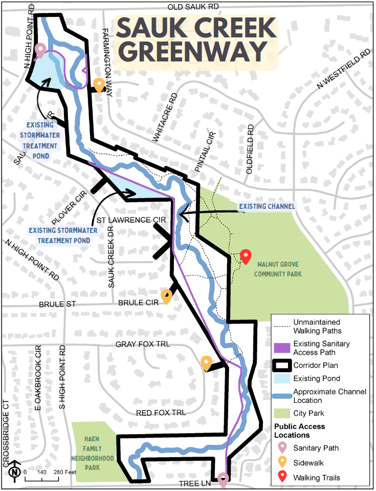
This project began based on the need to stabilize the stormwater channel, and create maintenance access. This is still the primary goal of any future construction project. However, due to the size and complexity of this greenway and adjacent ponds, including additional considerations for trees, vegeation, public use, mobility and accessiblity on public land, and based on the feedback that we received so far, we plan to re-start engagement with a broader approach. We are calling this broader approach a "Corridor Plan" because we are looking at the entire stormwater corridor. This includes the entire greenway (including the east-west section near Haen Family Park that wasn't in the original 2018 discussion), and the 2 adjacent, existing stormwater treatment ponds. Our first objective is to obtain community feedback on the greenway corridor as a whole, instead of as individual construction projects. Through this engagement process, we want to learn more about the community’s values and develop a conceptual plan for the corridor. There is currently no design for any element of the corridor, and there will be multiple public meetings and opportunities to provide input on the corridor plan as it develops. The final corridor plan will serve as a framework for future planning and construction phases of the greenway. Each construction phase will have a separate public engagement process to discuss more detailed design elements.
The corridor plan development will consist of a 7-step process where we plan to share information, and obtain input on specific aspects of the corridor.
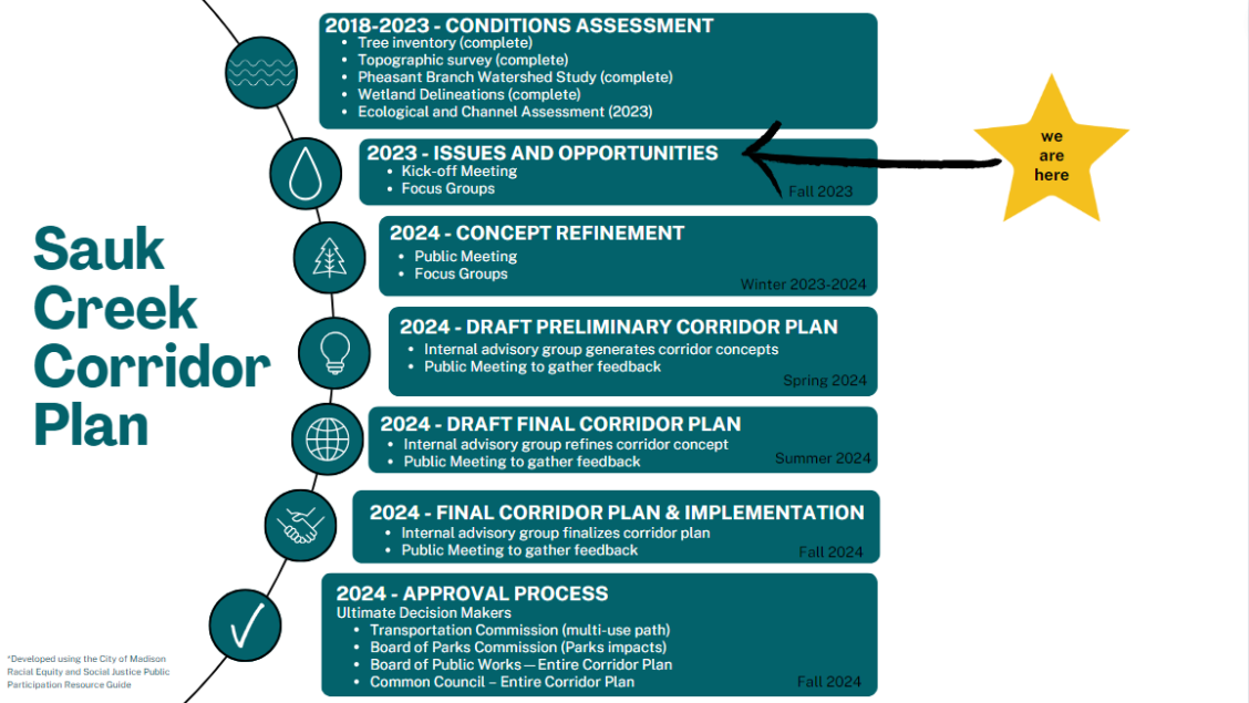
Public Engagement
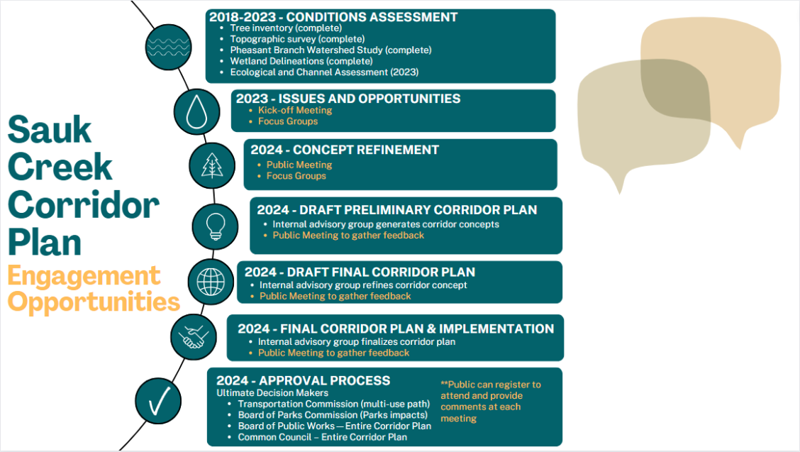
The components of the plan can be aggregated into 3 main areas—water, land and people and they are described below. Below, you can see the engagement opportunities within each step of the corridor plan.
The major takaways of the proposed engagement plan include:
- We will work together to develop a Corridor Plan
- The Corridor Plan will serve as a conceptual plan (not a design for construction)
- The Corridor Planning process will take more than 1 year
- This is a special engagement process developed based on what we heard from the community
- The kick-off meeting is focused on understanding community values and goals, and sharing baseline information. Detailed conversations will occur once more information is available
In late September, 2023, the City presented the engagement plan to presidents of adjacent neighborhood associations, as well as, to leaders of the Friends of Sauk Creek to obtain feedback on the proposed plan. The engagement plan, explained in detail in the presentation below, explains the aspects of the corridor vision the community can shape, and the timeline for the development of the plan. You can view the presentation below and the notes from the Feedback and Q&A following the presentation.
Sauk Creek Corridor Plan – Engagement Plan Meeting Presentation_9-26-23.pdf
Sauk Creek Corridor Plan –Engagement Plan Meeting Feedback and Q&A_9-6-23.pdf
Water
Storm events have eroded the existing Sauk Creek greenway channel banks. These eroded banks send sediment and nutrients downstream, fill in ponds and waterways, and contribute to harmful algae blooms. This has a negative impact on our downstream ponds, waterways, the Pheasant Branch Conservancy, and lakes Mendota and Monona. Stabilizing the banks of badly eroding channels is in alignment with the City of Madison Comprehensive Plan, Imagine Madison, to improve lake and stream water quality. And, in alignment with the Renew the Blue guide from the Yahara CLEAN compact, which specifically lists stabilizing drainage corridors as a recommended action. Additionally, in order to be compliant with State and Federal laws, we need to maintain stable stormwater channels.
As a result of the continued erosion, there are many trees adjacent to the channel that have fallen within the channel. This can reroute stormwater into new channels in the greenway, causing further erosion in a self-reinforcing cycle of erosion and subsequent tree loss.
Additionally, the City does not have access to the majority of the channel, apart from portions of the sanitary access road that are adjacent to it, to be able to remove fallen trees and larger blockages from the channel. To allow for future channel maintenance, and as part of any future construction project, a maintenance access path along the greenway is necessary.
The Sauk Creek Greenway is an important component of the Pheasant Branch Watershed. A comprehensive flood study was completed for this watershed following the August 20, 2018 flood event. Approximately ~1,230 acres of the watershed drain through this greenway! That results in ~260 cubic feet per second (CFS) of water flowing through the greenway during the 50% annual chance storm event (a type of summer storm we see most years). 1 cubic foot per second (CFS) can be hard to visualize. One way to put this into a bit of perspective is that one (1) CFS equals 450 gallons per minute (GPM), and a garden hose puts out approximately 12 GPM. So 1 CFS is equivalent to about 37 garden hoses (that is a lot of water).
The City continues to invest in green infrastructure solutions for public works, and stormwater regulations have been modified to require new developments that occurred after 2011, to infiltrate 90% of the water that previously infiltrated naturally prior to development. Additionally regulations were modified in 2020 that requires redevelopments that did not originally have infiltration requirements to now infiltrate 5% of the 10-year storm event. These efforts alone will not be sufficient to allow us to reach our flood targets throughout this watershed, due at least partially to all the development that occurred prior to any significant stormwater management requirements. As a result, we need to accommodate more stormwater in our main conveyance system, including the Sauk Creek greenway. The Sauk Creek greenway channel will be designed to be stable once upstream flood improvements are made so this channel will be stable for the next generation.
The consultant that is completing the Ecological and Channel Assessment will be analyzing the stormwater flows through the greenway from the Pheasant Branch watershed study and developing sample cross sections for the community to provide input on. One cross section will focus on tree preservation, and one cross section will focus on natural channel design. These cross sections will be shared during the Concept Refinement step (the public meeting in winter 2023-2024).
Land
Consultants completed a tree inventory of the entire greenway. The north-south section of the greenway was completed in 2017, and the east-west section of the greenway that runs parallel to Tree Lane was completed in 2020.
In addition to the tree inventory that was completed in 2017 and 2020, the City has hired a consultant to complete and Ecological Assessment to map and quantify the ecological communities, and their health, throughout the corridor. This information is actively being gathered and will be shared in early 2024 during the Concept Refinement stage. After sharing the results of the assessment, we will obtain feedback from the community and ask neighbors adjacent to the different distinct delineated ecological communities to provide input as well.
Trees and vegetation help with infiltration, slope stabilization, and erosion control. Those aspects play a critical part of the stormwater design. Additionally, trees and vegetation provide other ecosystem services such as urban canopy, pollinator habitat, carbon storage, health of residents, biodiversity, and wildlife habitat. Trees are a very valued part of the greenway and the City’s overall ecological health. While we are aware there is confusion surrounding this project, as a specific design has not been proposed, there is not an estimated number of tree removals to provide at this time. During the plan refinement process there will be tree impacts identified. See the engagement plan section for information on how the community’s input can shape the plan’s impacts on trees.
People
Residents have expressed concerns over safe, accessible and connected walking and biking for the neighborhoods surrounding the Sauk Creek Greenway. We understand that the Sauk Creek Greenway Corridor is an important public space for the community but can also be a barrier to reaching destinations that are close. It may also feel unclear whether you can walk or bike in the space currently.To help us craft a project that can work for the community and as a sustainable public works facility, the City wants to understand how the community currently uses the corridor, and wants to use the corridor in the future. We want to hear how this public space can strengthen connections between people and place. This valuable public space can benefit the community in multiple ways, not just as a storm water channel, and understanding the community’s values will help develop recommendations in the corridor plan to support people’s use and enjoyment of the Sauk Creek Greenway.
The West Area Plan is currently looking at transportation connections in the West Area, including potential connections in and across the Sauk Creek Greenway. The West Area Plan the best place to share input relating to the bicycle and pedestrian network and overall transportation safety. The Sauk Creek Greenway Corridor Plan will build upon any recommendations in the West Area Plan that impact the corridor and consider how to address:
- Community mobility/accessibility needs
- Design constraints
- Community concerns
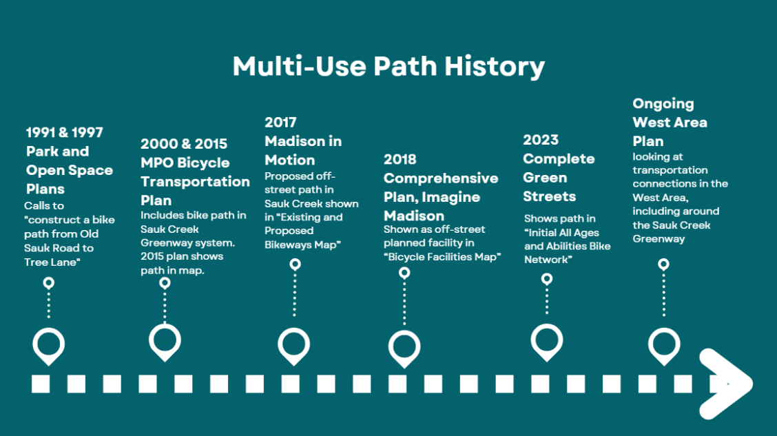
A multi-use path in Sauk Creek has been referenced in a variety of planning documents over the years as seen below:
In 2018, the Sauk Creek Greenway project was brought to the public and subsequently put on hold following the major flooding to complete watershed modeling. With the original 2018 project, the City Parks Division proposed an additional off-road trail network for mountain biking, snow shoeing, and skiing with the greenway project. These trails will not be considered with the Corridor Planning effort. Any future off road singletrack trail project will be managed by Parks and will be separate from the Sauk Creek Greenway project. You can learn more about the Parks Division’s planning project at their MadBAT project website.
Project Schedule
The Corridor Plan process is anticipated to last through 2024. In early 2025, the City will begin identifying the design phasing for this section (the phasing will be determined later in the corridor planning process) and develop a preliminary design based on the corridor plan. The detailed engineering design, as well as public engagement and final permitting, will last at least 6-9 months. Therefore construction will not begin in the corridor until fall 2025 at the earliest.
Public Involvement
There are a number of points of contact during this project where the public is encouraged to give feedback as part of public information meetings and City board and committee meetings. Dates and times are indicated below:
Public Information Meetings
-
Issues and Opportunities, Public Meeting (1 in person, 1 virtual), November 2023
- In-person: Monday, November 6 from 6:30-8:30pm at Vel Phillips Memorial High School, Wisconsin Neighborhood Center, Room 1210, 201 S Gammon Rd, Madison, WI 53717. Please enter at south entrance through the main doors, take a left, and room 1210 will be on your left. Please register for this meeting at this link on Eventbrite so we can make sure we have enough chairs and tables. There is no fee or ticket required to attend.
- Virtual: Thursday, November 9th from 6:30-8:30pm via Zoom. Registration prior is required. Please register at: Nov. 9, 2023 Public Information Meeting Registration
- Concept Refinement, Public Meeting, Winter 2023-2024
Meeting information will be posted when available
- Draft Preliminary Corridor Plan, Public Meeting, Spring 2024
Meeting information will be posted when available
- Draft Final Corridor Plan, Public Meeting, Summer 2024
Meeting information will be posted when available
- Final Corridor Plan & Implementation, Public Meeting, Fall 2024
Meeting information will be posted when available
City Meetings, Process
Transportation Comission: New information will be posted when available.
Board of Parks Commission: New information will be posted when available.
Board of Public Works: New information will be posted when available.
Common Council: New information will be posted when available.
Information Archive from Pre-Corridor Plan
A public information meeting was held for the original, proposed project March 13, 2018.
March 13, 2018 Public Information Meeting PowerPoint Presentation
Public Comments Received Through March 30, 2018
Separate, yet related public information meetings were held for the watershed this project is in.Three public information meetings for the Madison Pheasant Branch Watershed Study were held May 4, 2019, June 18, 2020 and February 10, 2022. The February 10, 2022 meeting was followed by a break-out group per proposed solution.
For more detailed information about the 2017 tree inventory, and the ability to view tree locations and ratings, please view the Sauk Creek Greenway Restoration Tree Survey Story Map .This map was created in 2018 and will be updated with the ecological assessment information in early 2024.
The Ecological Summary, authored by Tree Health Management after completing the 2017 tree inventory, can be found here: Sauk Creek Ecological Summary Each tree greater than 3” in diameter was surveyed and given a condition rating. This occurred from November-December of 2017. The collected Tree Data in Excel spreadsheet format can be found here: Tree Data
Engineering created a document that responds to frequently asked questions about the Sauk Creek Greenway Restoration Project in October 2022 to address the common questions at that time. The FAQ can be accessed here: Sauk Creek Greenway Restoration Frequently Asked Questions_October, 2022.
Sauk Creek Greenway Restoration Full Webpage Archive_10-13-23.