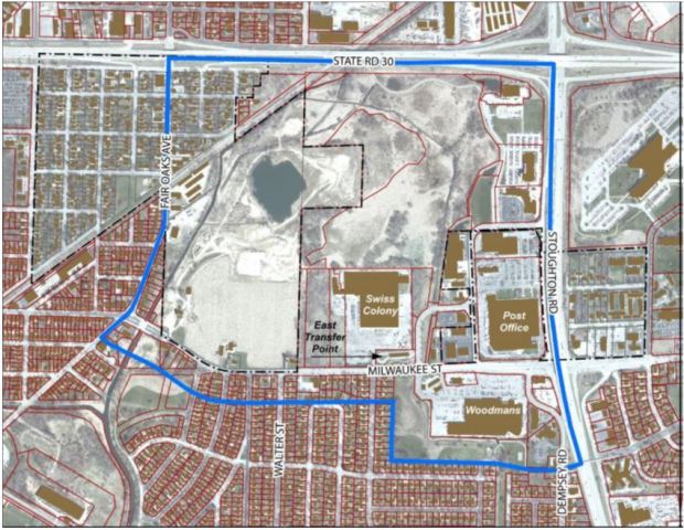
Milwaukee Street Special Area Plan
The City of Madison has initiated a joint planning process with the Town of Blooming Grove to create land use and transportation recommendations for the area generally bound by Milwaukee St., Fair Oaks Avenue, and Highways 51 and 30. While the Milwaukee Street Special Area Plan boundary contains approximately 300 acres, the focus will be on undeveloped areas and underutilized sites along nearly one mile of Milwaukee St. between Fair Oaks Ave and Highway 51.
The planning area, which abuts the Eastmorland and Worthington Park neighborhoods, contains several major commercial sites, including Woodman’s Food Market, the US Post Office and the Swiss Colony warehouse. Milwaukee St. is also home to Madison Metro Transit’s East Transfer Point, used by 15 bus routes providing the surrounding area with some of the highest levels transit service in the City.
North of Milwaukee St., the planning area transitions from urban to natural, with Starkweather Creek, wetlands and approximately 100 acres that will be preserved as open space.
This planning process will begin with a public open house, to be held at 6:30 pm on April 12 at Whitehorse Middle School, 218 Schenk St, Madison, WI 53704. The plan is anticipated to be completed by the end of 2018.
For additional information, visit the project website at http://www.cityofmadison.com/MilwaukeeSt or contact Dan McAuliffe with the City of Madison Planning Division at dmcauliffe@cityofmadison.com or 608-261-9676.
Contacts
- Dan McAuliffe, 608-261-9676., dmcauliffe@cityofmadison.com
Images