
Strickers/Mendota Watershed Study
Last Updated: 06/14/2023
Latest Update
7/26/2022 Update:
The Strickers/Mendota Watershed Study Final Report is now available for viewing.
Project Overview
The City of Madison undertook a watershed study in the Strickers/Mendota watershed (as shown below). The watershed study identified the causes of existing flooding and then created potential solutions to try to reduce flooding. The study used computer models to assist with the evaluations. A local consulting engineer, Brown and Caldwell, performed the study.
Still have questions? Get some answers here from our additional information page on the Watershed Studies.
For more information please see the Flash Flooding Story Map. *Note: Please view the story map using Firefox or Google Chrome browsers. Story maps are not viewable with Internet Explorer.
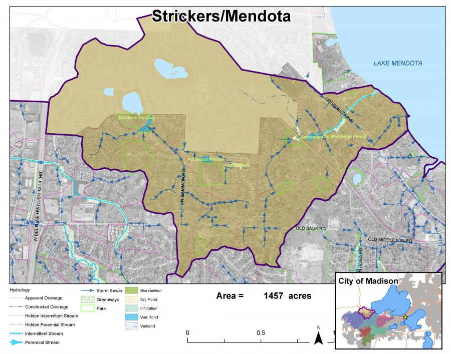
The Strickers/Mendota watershed drains to Lake Mendota.
Project Schedule
This study took approximately 24 months to complete. The first studies took longer as the City worked through the best processes and approaches for this new flood study initiative.
Final Report
The Strickers/Mendota Watershed Study Final Report is now available for viewing.
Public Involvement
Questions and comments can be emailed to the Project Contact at anytime. There were also a number of points of contact during this project where the public was encouraged to give feedback. Information is summarized below:
Public Information Meetings
- May 20, 2021 Strickers Mendota PowerPoint Presentation
- May 20, 2021 Strickers Mendota Public Information Meeting Recording
- March 9, 2020 Public Information Meeting PowerPoint Presentation
- April 22, 2019 Public Information Meeting PowerPoint Presentation
- Complete a survey to help City Engineering prioritize flooding improvement projects.
Focus Group Meetings
The City of Madison Engineering Division hosted four on-site Focus Group meetings in the Strickers/Mendota Watershed:
- Julia Street, Baker Avenue, 8-9 a.m., Aug. 27, 2019 Corner of Julia Street and Julia Ct.
- Hickory Hollow, 12-1 p.m., Aug. 27, 2019 15 Hickory Hollow Drive
- Baker Avenue, Lake Mendota, 6-7 p.m., Aug. 27, 2019 Corner of Baker Avenue and Lake Mendota Drive
- Longmeadow/Backbay Circle, 12-1 p.m., Sept. 9, 2019 Stricker's Pond Pedestrian Path, 7214 Longmeadow Road
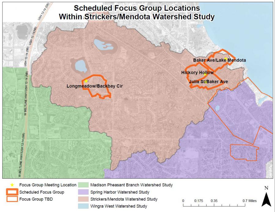
The meetings were requested by community members, and were open to the public, but the conversation was tailored to gather more information on flooding issues in the meeting area. During the focus group meetings, engineers met with groups of residents on site, in specific areas hit the hardest by flooding in the past few years, including the August 2018 flood event. The purpose of the focus group meetings was to gather flooding information based on residents’ experiences.
Information about Focus Groups
Public Comment Period
A 30-day Public Comment Period was held for the public to review the Draft Final Report and provide comments. The public comments and response to comments are included in the Final Report.
Prioritization Survey
There are many proposed recommendations from each watershed study. The cost of the recommendations far outweighs the City's budget to implement them. The public is asked to complete a survey to help the City prioritize which solutions are implemented first.
Complete a survey to help City Engineering prioritize flooding improvement projects.
Existing Conditions Flood Mapping
The watershed model evaluated numerous design storm events. The City created an online viewer for the 1% chance (100-yr) storm event. It can be found here.
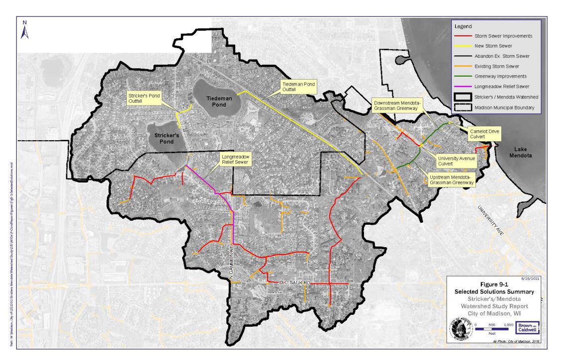
Proposed Flood Reduction Solutions
The watershed study resulted in many proposed flood reduction solutions. These solutions are concepts and show what it would take to meet the City's flood reduction targets. Only solutions included in the Capital Improvement Program budget are in process of design or construction; public outreach efforts are conducted for those projects separately from this study. The map below shows the locations and extents of the proposed solutions. Concepts for individual solutions can be found in the Final Report.
Background
The City of Madison has 22 watersheds. Watersheds are an area of land that drain to the same location (the outlet).There is a stormwater drainage system in all watersheds. This system is what conveys the stormwater to the outlet of the watershed.
The current statistics on the City of Madison's stormwater drainage system can be found on the Stormwater webpage.
The City's system dates back to the 1880s. Very few, if any, standards were available in the 1880s. As the City developed, so did the guidance for design and construction. Today, we have comprehensive City, State, and Federal regulations to guide design and construction. The area of the City you live in used the regulations in place at the time it was developed. You can view the StoryMap to see what the regulations were for your neighborhood.
The extreme storm events in 2018 shed light on the deficiencies of the City’s stormwater drainage system. Many areas of the City experienced devastating flooding. This prompted the City to begin a comprehensive watershed study program in 2019. The intent of the program is to study each of the City’s watersheds one-by-one. The studies will help us to understand the causes of flooding. The studies will also provide recommended solutions to reduce the risk of flooding.
The watershed studies result in a list of proposed mitigation measures. Once constructed, the measures will reduce the risk of flooding to specific areas of the City. These mitigation measures are generally very costly. Due to limited stormwater management funding, all the mitigation measures cannot be implemented at one time.
The average Stormwater Utility Capital Budget each year is approximately $12 million. Within that, an average of about $2.4 million is used for flood mitigation. As of late 2021, recommended flood mitigation measures for the first five watershed studies were identified. The total cost from the first five studies is approximately $125 million. We expect the remaining 17 watershed studies will have similar flood mitigation project needs. Implementation of these flood mitigation measures will take many decades.
The Stormwater Utility funds the stormwater management for the City. This includes the construction, operation, and maintenance of the entire stormwater drainage system. The Stormwater Utility rates are set each year consistent with Wisconsin Statute. § 66.0821(4) and as described in Madison General Ordinance section 37.05 . These rates are under the purview of the public service commission. The rates are required to be deemed “reasonable” to comply with state statute. During the annual budgeting process, the City tries to balance the stormwater needs with the stormwater rate charged to its customers. These needs include:
- Implementation of flood mitigation measures
- Replacement, extension, and upgrades of existing the existing stormwater system
- Mandated water quality needs and requirements
When possible, the City attempts to get grant funding to partially fund the flood mitigation measures. Grant funding makes up a small part of the funding needed for stormwater management.
The City has created a draft prioritization process. This process creates a proposed order to construct the flood mitigation measures. This process accounts for many factors including:
- Impact on emergency services,
- Location of vulnerable populations,
- If the project also improves stormwater quality,
- Whether other projects are occurring nearby, and
- If outside funding is available.
Additional Resources
- City of Madison Flood Website
- Take the survey as the City works to learn more information to prioritize flooding projects.
- Flash Flooding Resilience Story Map *Note: Please view the story map using Firefox or Google Chrome browsers. Story maps are not viewable with Internet Explorer.
- Watershed Study Learning Hub
- View the City's Annual Stormwater Newsletter: Waterways
- Watershed Studies 2019 Audio Presentation
- Flood Prevention Flyer and website
- Everyday Engineering Podcast Episode: Basement Drainage
- Everyday Engineering Podcast Episode: Historic Flooding
- Everyday Engineering Podcast Episode: What's going on with the Watershed?
Report Flooding
If anyone has experienced flooding, and is willing to share with the City, please report it on the City's website. Even if a homeowner reported flooding to 2-1-1, FEMA, or a City official, the City needs standardized information to create stormwater models that show existing flooding conditions. The flood data helps the City prioritize different flood projects and future watershed studies. Please report any flooding you’ve experienced.