
Mendota-Grassman Greenway Flood Mitigation and Restoration Design
Last Updated: 08/30/2023
Latest Update
8/30/23 Update:
Project's construction status has been updated to construction.
Construction Timing
The City bid this project to be constructed from Dec.1, 2023 through 2024 with restoration efforts continuing into 2025. The greenway work will begin in the winter of 2023-2024 and continue through 2024. The Camelot Drive culverts and University Ave culvert will be replaced in 2024.
3/7/23 Update:
Construction Timing and Maintenance Path Details
The City is planning to bid this project to be constructed from summer 2023 through 2024 with restoration efforts continuing into 2025. The University Avenue culvert will be replaced either in 2023 or 2024 and greenway work will begin in the winter of 2023-2024 and continue through 2024. The Camelot Drive culvert will be replaced in 2024.
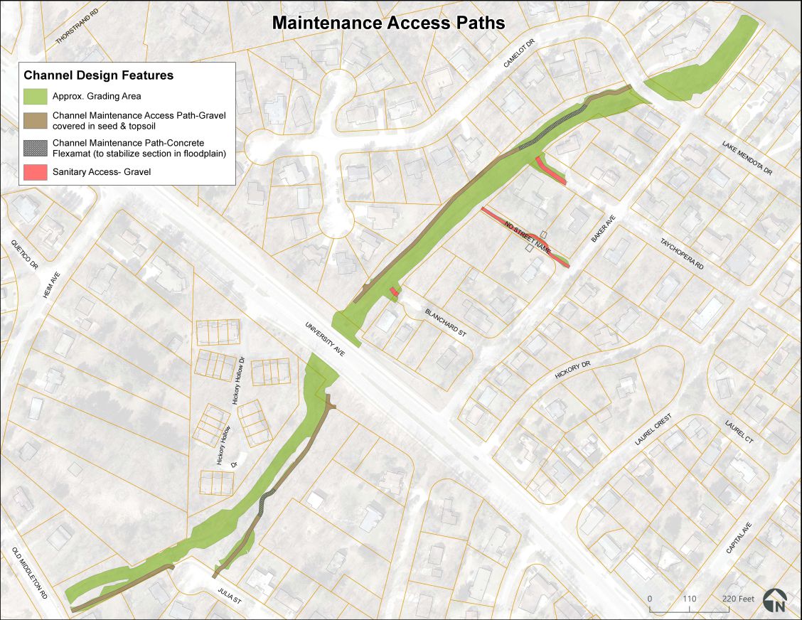
There have been questions related to the channel maintenance access path and what it will look like following construction. The proposed maintenance access path will run parallel to the channel to provide for maintenance access to the main conveyance channel (this is not for sewer cleaning). The purpose of the channel maintenance access path is to clear the channel of debris, down limbs, down trees, or repair sections of channel as needed. Building this type of maintenance access allows for us to replant the greenway with a significant amount of trees without the risk that we will not be able to maintain a wooded channel. As was explained in the public information meeting, the maintenance for this channel is extra important as our modeling shows that we are just able to reach our flood mitigation targets (no flooding in a 1% annual chance storm) when the channel clear without any blockages. Due to the high flood risk, and the City’s dedication to maintaining restored stormwater infrastructure, we need to build in maintenance access for the entire length of the channel.
The proposed channel maintenance access path will be built of gravel so that small equipment can drive on it. At the neighbors request, we will be topping the majority of the channel maintenance access path with topsoil and seed (native path rush). The vegetation on the path will be shorter than the rest of the greenway so that the path can be easily located by maintenance staff. To ensure the path doesn’t wash out, there is additional reinforcement called out for different sections of the path depending how frequently and how deep the channel maintenance access path will flood. There are some areas where a “geoweb geocell” will be installed—this is a high density polyethylene (HDPE) webbing that is filled with the gravel. The webbed pockets help hold the gravel so that it cannot be easily washed away. Additionally, in very limited areas where the access path dips into the designed floodplain (near Taychopera Rd, and near Julia St—see map below), we will be installing a Flexamat material, or a similar concrete webbed grid, over the gravel to stabilize the access path. The additional reinforcement was added based on the modeled frequency and velocities of the flood water in the newly constructed channel. The concrete flexamat sections cannot be topped with topsoil and seed like the rest of the path.
The sanitary access paths (mapped below in red) are designed more robustly for our large sanitary vactor trucks to access sewer structures for cleaning. They are gravel and cannot be topped with topsoil. It is important for the City to complete preventative maintenance (sewer cleaning) to reduce the number of sewer back-ups. The sanitary access paths also allows for emergency access which can help control back-up issues if or when they occur.
Project Overview
The City of Madison, like many communities, has seen a recent increase in extreme flood events. This increase has occurred most notably in Madison since 2016, when a large and intense rain event in late July caused extensive flooding of public and private property on Madison’s west side. Large events in July 2017 and June 2018 caused similar flooding, again largely focused on Madison’s west side.
On August 20, 2018, Dane County experienced an unusual precipitation event that caused flooding in excess of that seen in any of the prior events mentioned. Rain gages monitoring that event registered between 8-10” of precipitation on its west side over (approximately) a 12-hr period. Many of Madison’s west side neighborhoods experienced flash flooding, resulting in millions of dollars in property damage.
In response to the damage incurred, as well as the likely increasing frequency of such events due to global climate change, the Madison Common Council authorized the City of Madison Engineering Division (City Engineering) to develop watershed models and plans for watersheds of greatest concern in the Madison area. The redesign of this greenway system is a solution resulting from of one of these studies.
In the spring of 2021 the City will finish a watershed study for the Stricker’s/Mendota watershed that encompasses this area. The purpose of that study is to evaluate existing conditions in the watershed and look for solutions for flood reduction. Homes adjacent to this greenway have repeatedly flooded in the past and the preliminary proposed solutions for this watershed study indicate the best solution for this area is to maximize conveyance.Due to the chronic flooding in this neighborhood, the fact that the City had budgeted a project in this greenway prior to the watershed study, and the minimal variables that could impact the design possibilities as the watershed study refines the solutions, the City has decided to hire a consultant to work on the design of this greenway in earnest. The City of Madison has hired MSA complete the flood mitigation and restoration design starting in December of 2020.
Project Limits
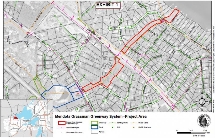
View full Mendota Grassman Greenway System Project Area map.
Along the greenway that runs southwest to northeast from Old Middleton Road to Lake Mendota.
Between Baker Avenue and Heim/Camelot Drive
Restoration and Tree Removals
The City has been approved for a tree removal permit. Below please find additional information about the tree removal and restoration plan:
- Tree Removal Plan Overview
- Habitat Stewardship Subcommittee Presentation Slides (showing updated tree removal data from the public information meeting #2 and a draft restoration plans)
- For more background, please watch the recording of the Public Information Meeting #2 from 31:30 to 1:04:00. This is a detailed presentation on draft tree removal plan and restoration plans for the greenway.
- Ecological Restoration in Stormwater Ponds and Greenways Story Map
- Tree removal plan sheets
- Tree Inventory in Project Area
- Draft Restoration Plan
Project Schedule
The project will be under construction in 2023-2024 with restoration efforts continuing into 2025.
Public Involvement
There are a number of points of contact during this project where the public is encouraged to give feedback as part of public information meetings and public hearings. Dates, times and locations are indicated below:
Public Information Meetings
Oct. 3, 2022 Public Information Meeting Recording
Oct. 3, 2022 Public Information Meeting PowerPoint Presentation
May 25, 2021 Public Information Meeting Recording
May 25, 2021 Public Information Meeting PowerPoint Presentation
City Process, Meetings
Board of Public Works: March 8, 2023
Common Council: March 21, 2023
*Note: Registering to speak is only necessary for Common Council and Board of Public Works Meetings. You do not need to register to speak at Public Information Meetings. Simply attend with registration, and you'll have an opportunity to share feedback and ask questions.
Learn more about attending and speaking at the public hearings virtually.
Watch Meetings Online
City Meeting Schedule