
East Isthmus and Yahara River Watershed Study
Last Updated: 08/29/2023
Latest Update
10/10/2022 Update:
Thank you to everyone who attended the Oct. 6, 2022 Public Information Meeting. The meeting materials are now available:
Oct. 6, 2022 Public Information Meeting Recording
Oct. 6, 2022 Public Information Meeting PowerPoint Presentation PDF
You can also view a Story Map called, “East Isthmus Yahara Watershed Study Flood Mapping ” that describes how lake level flooding is addressed in the East Isthmus Yahara River Watershed Study. Note: Please view the story map using Firefox or Google Chrome browsers. Story maps are not viewable with Internet Explorer.
Additionally, during the public meeting, people had many questions about the Yahara Watershed lake levels and the County’s sediment removal program, which is a separate effort from the watershed study. The watershed study is looking at the risk of flash flooding on the isthmus due to storm sewers not being able to drain the stormwater quickly enough, and the next phase of the study will look at solutions the City is able to implement in order to meet the City’s flood targets. The Yahara River sediment removal program is a separate, but connected issue, as decreasing lake levels will lower the flash flood risk on the isthmus. Here are some links from Dane County that explore the lake level topics separately:
· Yahara Lake Level Recommendations
· Yahara River Sediment Removal
Project Overview
The City of Madison will complete a watershed study in the East Isthmus and Yahara watershed (as shown below). The watershed study identifies causes of existing flooding and then crafts potential solutions to try to reduce flooding. The study uses computer models to assist with the evaluations.
The City of Madison has hired a consultant, Tetra Tech, Inc to complete the first half of the study where the existing conditions are modeled.
View the City's Story Map: East Isthmus Yahara Watershed Study Flood Mapping, which describes how lake level flooding is addressed in the East Isthmus Yahara River Watershed Study. Note: Please view the story map using Firefox or Google Chrome browsers. Story maps are not viewable with Internet Explorer.
For more information on how general flash flooding happens, view the City's Story Map: Flash Flooding Story Map. *Note: Please view the story map using Firefox or Google Chrome browsers. Story maps are not viewable with Internet Explorer.
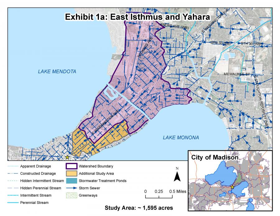
The East Isthmus & Yahara study area drains primarily to the Yahara River and parts on the far east and west sides of the watershed drain directly to Lake Monona. The study extends west past the isthmus Yahara River watershed because the surface water is connected to an area that drains directly to Lake Monona and it’s important to study both together.
Still have questions? Get some answers here from our additional information page on the Watershed Studies.
Project Schedule
The study is beginning Spring 2020 and is expected to take over 24 months. During this time, the City will look at watersheds as a whole to understand the interaction of flash flooding and the increased risk of flooding due to high lake levels. The East Isthmus and Yahara River watershed study will be done in two phases where a consultant will first develop an existing conditions model and analyze the impact of the Yahara River elevations on localized flash flooding. Following the completion of that work, the City will set up a separate contract for the solutions phase of the study.
Public Involvement
Questions and comments can be emailed to the Project Contact at anytime. There were also a number of points of contact during this project where the public was encouraged to give feedback. Information is summarized below:
Public Information Meetings
- Oct. 6, 2022 Public Information Meeting Recording
- Oct. 6, 2022 Public Information Meeting PowerPoint Presentation
- Aug. 26, 2020 Public Information Meeting No. 1 PowerPoint Presentation
- Aug. 26, 2020 Public Information Meeting No. 1 Recording
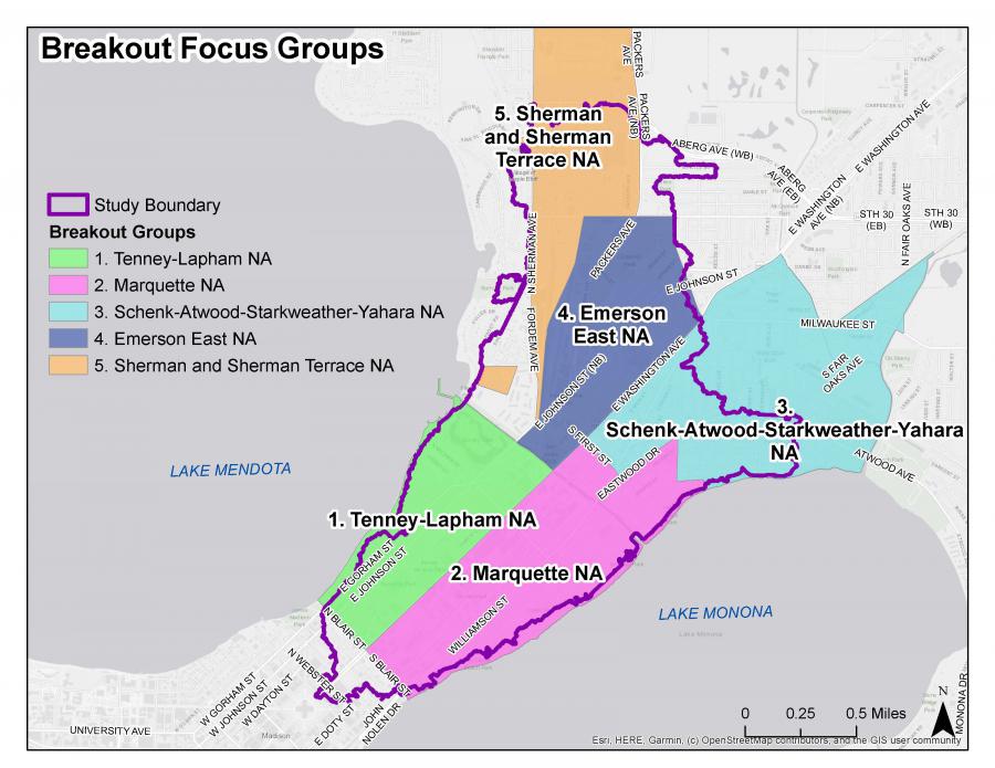
- Following the presentation, participants had an opportunity to break out into smaller “focus groups” to discuss neighborhood-specific flooding issues. If you are unsure which neighborhood you live in, you can search your address in the top left corner of the neighborhood look-up map. The non-interactive map showing the focus groups is shown below:
If you don’t have access to a computer or smart phone, set up an appointment to use computers to view the presentation at a City of Madison Library, or at the UW Memorial Library. You can also register online and receive a phone number to dial into the meeting from any phone. Additionally, you can set up a time to view the recorded presentation on a library computer once the presentation is posted (a few days following the meeting).
Prioritization Survey
There are many proposed recommendations from each watershed study. The cost of the recommendations far outweighs the City's budget to implement them. The public is asked to complete a survey to help the City prioritize which solutions are implemented first.
Complete a survey to help City Engineering prioritize flooding improvement projects.
Report Flooding
If anyone has experienced flooding, and is willing to share with the City, please report it on the City's Report Flooding Portal. Even if a homeowner reported flooding to 2-1-1, FEMA, or a City official, the City needs standardized information to create stormwater models that show existing flooding conditions. The flood data helps the City prioritize different flood projects and future watershed studies.
The key to good reporting is including specific details and visuals.
If it is possible to do so safely, collect the following information when it is flooding:
- Date of the flooding
- Total time flooding occurred
- The time the flood water reached its highest point
- Photos of flooded areas when they are the most flooded
- Videos showing how the water is moving into and out of the flooded area
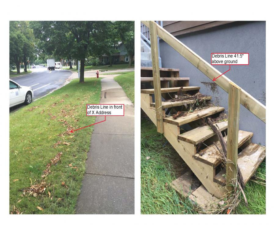
Once the flood waters have receded, and it is safe to do so, look for clues of the flood waters extent and depth. Clues include:
- Debris lines outside (twigs, leaves, dirt are left behind in a line on the lawn, sidewalk, mailbox post, shrub etc)
- Border of disturbed vegetation—if half the vegetation has been bent or is stuck to the ground in the direction of the flow, you can see the reach of the flood water
Document these clues and measure any depths where debris lines are above the ground. Pictures with descriptions are very helpful. For example:
If you were unable to capture any photos, descriptions are also helpful:
- Flood water reached the base of the first step on the front walk of our house at X address.
- Flood water was 12” deep at the mailbox in front of X address.
Background
The City of Madison has 22 watersheds. Watersheds are an area of land that drain to the same location (the outlet).
There is a stormwater drainage system in all watersheds. This system is what conveys the stormwater to the outlet of the watershed. The current statistics on the City of Madison's stormwater drainage system can be found on the Stormwater webpage.
The City's system dates back to the 1880s. Very few, if any, standards were available in the 1880s. As the City developed, so did the guidance for design and construction. Today, we have comprehensive City, State, and Federal regulations to guide design and construction. The area of the City you live in used the regulations in place at the time it was developed. You can view the StoryMap to see what the regulations were for your neighborhood.
The watershed studies result in a list of proposed mitigation measures. Once constructed, the measures will reduce the risk of flooding to specific areas of the City. These mitigation measures are generally very costly. Due to limited stormwater management funding, all the mitigation measures cannot be implemented at one time.
The average Stormwater Utility Capital Budget each year is approximately $12 million. Within that, an average of about $2.4 million is used for flood mitigation. As of late 2021, recommended flood mitigation measures for the first five watershed studies were identified. The total cost from the first five studies is approximately $125 million. We expect the remaining 17 watershed studies will have similar flood mitigation project needs. Implementation of these flood mitigation measures will take many decades.
The Stormwater Utility funds the stormwater management for the City. This includes the construction, operation, and maintenance of the entire stormwater drainage system. The Stormwater Utility rates are set each year consistent with Wisconsin Statute. § 66.0821(4) and as described in Madison General Ordinance section 37.05 . These rates are under the purview of the public service commission. The rates are required to be deemed “reasonable” to comply with state statute. During the annual budgeting process, the City tries to balance the stormwater needs with the stormwater rate charged to its customers. These needs include:
- Implementation of flood mitigation measures
- Replacement, extension, and upgrades of existing the existing stormwater system
- Mandated water quality needs and requirements
When possible, the City attempts to get grant funding to partially fund the flood mitigation measures. Grant funding makes up a small part of the funding needed for stormwater management.
The City has created a draft prioritization process. This process creates a proposed order to construct the flood mitigation measures. This process accounts for many factors including:
- Impact on emergency services,
- Location of vulnerable populations,
- If the project also improves stormwater quality,
- Whether other projects are occurring nearby, and
- If outside funding is available.
Additional Information
-
Flash Flooding Resilience Story Map *Note: Please view the story map using Firefox or Google Chrome browsers. Story maps are not viewable with Internet Explorer.
- Lake Level Flooding Story Map *Note: Please view the story map using Firefox or Google Chrome browsers. Story maps are not viewable with Internet Explorer.
- Watershed Studies 2019 Audio Presentation.
- Watershed Study Learning Hub
- City of Madison Flood Website
- View the City's Annual Stormwater Newsletter: Waterways
- Flood Prevention Flyer and website
- Dane County's Yahara River Sediment Removal Project
- Dane County's Flood Facts and Initiatives
- Download the Engineering's Podcast: Everyday Engineering on iTunes and Google Play.